The aim of this project is to develop effective methods that combine the use of multiple data sources (satellite and drone observations and ground-based sensors) to monitor the spread of invasive aquatic weeds in neglected and inaccessible water bodies in India. The project focuses on water hyacinth (Eichhornia crassipes) in the Kuttanad region of Kerala.
Invasive aquatic weeds are a serious problem affecting many parts of Asia and Africa. They cause severe degradation of the aquatic environment, with damaging impacts on fisheries, drinking water sources, agricultural irrigation, rice cultivation, navigation and recreational use of water bodies. Lakes become breeding grounds for mosquitoes, carrying diseases such as Chikungunya that endanger human health. The effects are felt severely in the Kuttanad basin in central Kerala, where agriculture and the tourism industry depend heavily on the local lakes and rivers, almost all of which are heavily infested with water hyacinth (WH).
Attempts to control the weed usually involve manual or mechanical removal. However, it is impossible to remove all traces of the weed completely, and it regenerates from left-behind seeds and fragments. Regrowth in small, neglected and inaccessible side streams and pools remains undetected until the spread is extensive and has reached economically important water bodies which become re-infected and damaged. Early detection of regrowth has the potential to cut the cost of control by allowing the weed to be removed before it has reached a damaging level.
We investigate technological methods for early detection of water hyacinth regrowth, combining data from satellite, drone, and ground-level sensors. Multi-modal data has the benefit of providing both extensive area coverage and sufficient resolution to survey small water bodies. We will devise algorithms for combining multi-modal data for effective detection, carry out pilot trials of our methods, and ensure sustainability of results through training and dissemination activities.
Work Package 1 (WP1): Requirements gathering
WP1 will establish essential communication and common understanding of the project goals and activities through a series of meetings of the project team and other stakeholders to capture the requirements for the proposed software and systems, and the context and constraints under which the systems will need to operate when deployed in India. These meetings will include local environmental scientists in Kerala, to advise on the use of IoT sensor networks in local water bodies; weed scientists from ICAR-Directorate of Weed Research, to advise on the biology and life cycle of WH; and environmental managers and policymakers.
Work Package 2 (WP2): Multimodal data collection
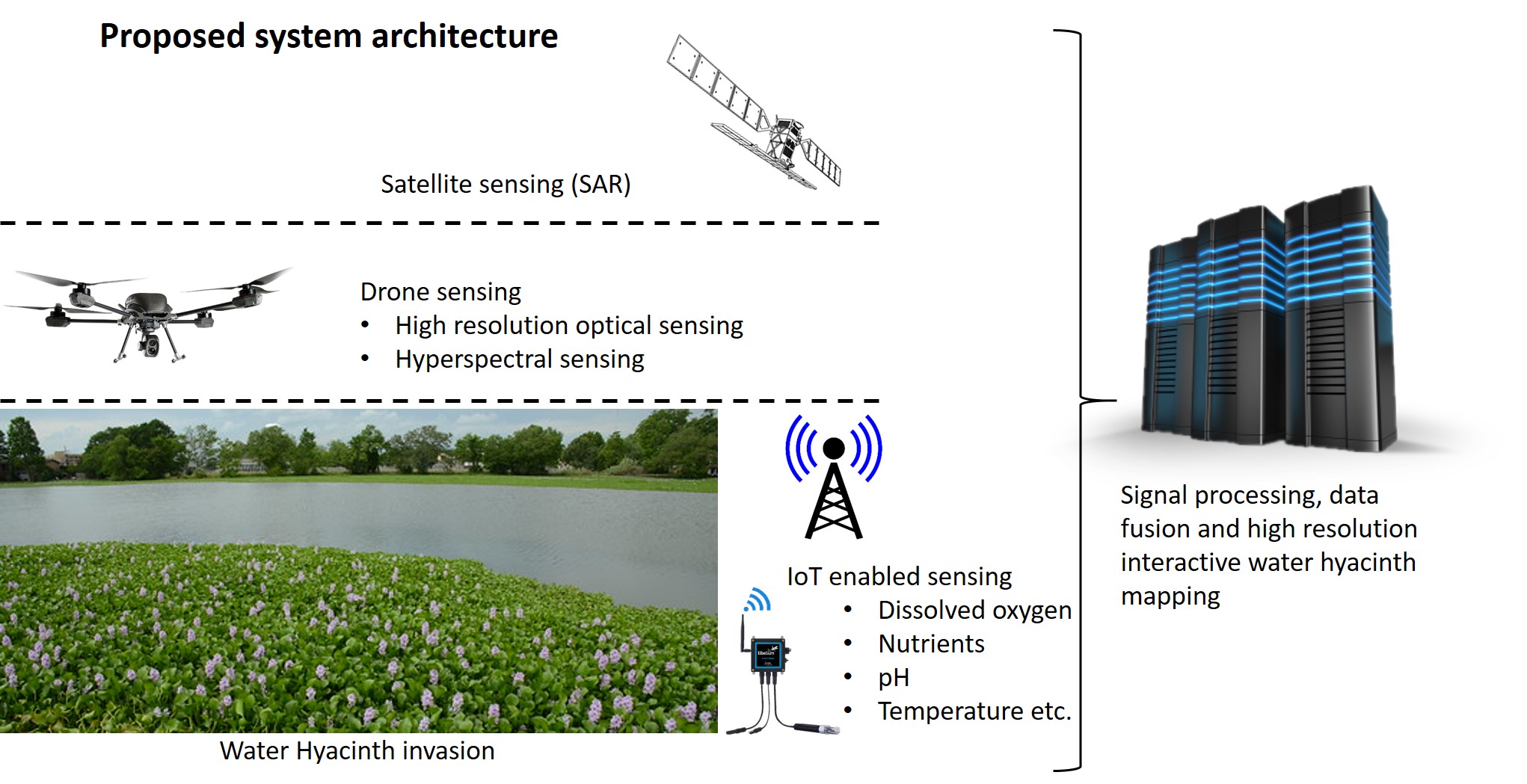
A key innovation in this project is the integration of complementary, multimodal environmental data sets from satellites, drones, and ground based sensors. For satellite data we will make use of the global coverage of recent satellites, e.g., SAR RISAT-2BR1 from the Indian Space Research Organisation (ISRO), and SAR Sentinel-1 from the European Space Agency. Data will provide direct information about WH through colour, lake surface texture, reflectance and other indicators. We'll also capture the full WH life cycle information using multispectral data using repeated drone survey campaigns at Kuttanad. IoT enabled ground sensors will provide data remotely from water, such as dissolved oxygen, nutrient concentrations, temperature etc. that are indirect indicators of stages of WH growth. Analysis of such time series data will give us substantial understanding of the WH growth pattern.
Work Package 3 (WP3): Data driven algorithmic development
WP3 will develop robust signal and image processing algorithms that can be used to map WH coverage using input from satellite, drone and ground sensor data. A feature extraction algorithm will be developed to identify WH presence in satellite imagery. We will use a hybrid approach that combines traditional signal processing with state-of-the-art deep learning methods and emerging transfer learning techniques. Training and testing of the algorithm will be done using data collected from WP2, with satellite images as input and drone images providing ground truth for training and testing. WP3 also intend to create an application programming interface (API) to facilitate integration of our algorithms into larger software systems.
Work Package 4 (WP4): Results dissemination and legacy planning
In WP4, there will be research staff exchange in both direction, i.e., India to UK and UK to India to disseminate the outcome. For example, in year 2, two NIPHM staff will visit the UK for training in the methods developed. In year 3 we will carry out other dissemination activities, including an end of project workshop in Kerala. We will hold discussions about the legacy of the project and ensuring that the work continues in follow-on projects, with particular emphasis on implementing the findings of the current project on a wider scale within India and other countries affected by aquatic weeds.